PUDUCHERRY: Leaving major devastation in its wake, Cyclone Thane hit landfall between the Union territory of Puducherry and neighbouring Cuddalore district in Tamil Nadu at about 9 am.
"Cyclone Thane has hit landfall between Cuddalore and Puducherry at about 9am and is presently in retreat mode. It will take another hour for the fury to abate," said Puducherry collector S B Deepak Kumar. One person was killed in a house collapse in Puducherry, he told TOI.
As it passed the coastal Puducherry and the sea-side Cuddalore town and villages, the cyclone vented its fury, uprooting trees and electric posts. Power supply had been cut 12 hours ahead of the expected cyclone landfall. "Damages are extensive in Puducherry. We are waiting for the cyclone to retreat before doing an assessment," said Kumar. Several main roads and interior streets from Puducherry to Cuddalore looked like a war zone, strewn with uprooted trees and electric posts.
The territorial administration as well authorities in Cuddalore district had geared up for a possible calamity, evacuating villagers from coastal hamlets and those falling within the danger zone to cyclone shelters on Thursday. The preparations for Cyclone Thane had begun well before it was expected to hit landfall.
Met officers said Cyclone Thane took about three hours to cross coastal Tamil Nadu near Cuddalore and Puducherry. "We are getting reports regarding extensive damages caused due to cyclone", a senior met officer said. He said the cyclone is severe this time since rainfall is less. There will be gradual decrease of rainfall and wind, he said.
Source:- http://timesofindia.indiatimes.com/india/Cyclone-Thane-makes-landfall-between-Cuddalore-and-Puducherry-devastates-area/articleshow/11301526.cms
Friday, December 30, 2011
Cyclone Thane Hits Puducherry Tamil Nadu 6 Dead
Severe cyclonic storm "Thane" today lay centred very close to Puducherry and was likely to cross Tamil Nadu coast in a few hours and bring in 145 kmph of gale winds.
"The very severe cyclonic storm 'Thane' over south west Bay of Bengal moved further westward and lay centred very close to south east of Puducherry. The system is likely to move westwards and cross north Tamil Nadu coast close to south Puducherry within a few hours and weaken gradually", the regional weather office said.
The cyclonic storm brought in copious overnight rainfall coupled with squally winds uprooting trees in some places of Chennai and elsewhere.
Weather officials said heavy rainfall to extremely heavy rainfall ranging up to 25 cms would occur at many places over north Tamil Nadu, Puducherry coastal Andhra Pradesh and Rayalaseema.
Gale winds with a maximum speed of 145 kmph was likely in the next few hours and it would then decrease gradually, it
said, adding maximum wind speed of 115 kmph to 125 kmph had ben recorded early this morning.
The sea condition was phenomenal along and off north Tamil Nadu, Puducherry and adjoining south Andhra Pradesh coast, the weather office said and advised fishermen against venturing into the sea.
Meanwhile, flight services were also disrupted due to the cyclonic storm with four international services, including those bound for Kuwait and Kuala Lumpur were cancelled.
The state government had declared holiday for educational institutions in coastal districts, including Chennai, Cuddalore and Tiruvarur today.
The government said it has put in place measures to face the effect of the storm, with special teams of officials formed to monitor the situation. PWD Secretary M Saikumar had held a meeting yesterday and discussed steps to be taken on a 'war footing' to tackle the effects of the storm.
Source:- http://www.expressindia.com/latest-news/Cyclone-Thane-leaves-6-dead-in-Tamil-Nadu-Puducherry/893845/
Thursday, December 29, 2011
Very Severe Cyclonic Storm THANE over southwest Bay of Bengal:-Cyclone Warning for north Tamilnadu and south Andhra Pradesh coast : Orange Message
The very severe cyclonic storm THANE over southwest Bay of Bengal moved west-southwestward and lay centered at 0530 hrs IST of today, the 29th December 2011 near latitude 12.30N and longitude 83.00E, about 300 km east-southeast of Chennai (Tamilnadu) and 480 km north-northeast of Trincomalee (Sri Lanka). The system is likely to move westwards and cross north Tamil Nadu coast between Nagapattinam and Chennai, close to Puducherry around morning of 30th December 2011. However, as the cyclonic storm will come further close to coast, there is probability of slight weakening before landfall.
Based on latest analysis with NWP models and other conventional techniques, estimated track and intensity of the system are given in the Table below:
Date/Time(IST)
Position (lat. 0N/ long. 0E)
Sustained maximum surface wind speed (kmph)
Intensity
29-12-2011/0530
12.3/83.0
120-130 gusting to 145
Very Severe Cyclonic Storm
29-12-2011/1130
12.0/82.3
120-130 gusting to 145
Very Severe Cyclonic Storm
29-12-2011/1730
12.0/81.5
110-120 gusting to 135
Severe Cyclonic Storm
29-12-2011/2330
12.0/80.7
110-120 gusting to 135
Severe Cyclonic Storm
30-12-2011/0530
12.0/80.0
100-110 gusting to 125
Severe Cyclonic Storm
30-12-2011/1730
12.0/78.6
65-75 gusting to 85
Cyclonic Storm
31-12-2011/0530
12.0/77.2
55-65 gusting to 75
Deep Depression
31-12-2011/1730
12.0/75.8
45-55 gusting to 65
Depression
Under the influence of this system, rainfall at most places with isolated heavy rainfall is likely over north Tamil Nadu & Puducherry and south coastal Andhra Pradesh from today morning, the 29th December 2011 onwards. The intensity of rainfall would increase with heavy to very heavy falls at a few places and isolated extremely heavy falls (25cm or more) from today evening onwards and extend to Rayalseema and north interior Tamil Nadu.
Squally winds speed reaching 45-55 kmph likely to commence along and off north Tamil Nadu, Puducherry and south Andhra Pradesh coasts from today morning The wind speed will increase gradually from today night onwards becoming 100-110 kmph gusting to 125 kmph along and off north Tamilnadu and south Andhra Pradesh coast at the time of landfall.
Storm surge of about 1 meter height above the astronomical tide would inundate the low lying areas of Chennai and Tiruvallur, Kanchipuram & Villupuram districts of north Tamil Nadu at the time of landfall.
Sea condition will be high to very high around the system centre. Sea condition will be high to very high along and off north Tamil Nadu, Puducherry and south Andhra Pradesh coasts from today night onwards.
Fishermen along north Tamil Nadu, Puducherry & south Andhra Pradesh coasts are advised not to venture into sea. Those who are out at sea are advised to return to the coast.
Damage expected (over north coastal Tamil Nadu and south coastal Andhra Pradesh): Extensive damage to thatched roof and huts. Minor damage to power and communication line due to uprooting of large avenue trees. Flooding of escape routes.
Action suggested (over north coastal Tamil Nadu and south coastal Andhra Pradesh): Total suspension of fishing operations. Coastal hutment dwellers to be moved to safer place. People in affected areas to remain indoors.
Source:- http://www.imd.gov.in/section/nhac/dynamic/cwind.htm
Wednesday, December 28, 2011
EALA roots for disaster experts in the region
As Dar es Salaam grapples with devastating floods, the East African Legislative Assembly (Eala) says policymakers should fully involve scientific experts and technocrats in disaster management in a bid to reduce and build resilience against catastrophes.
The Speaker, Mr Abdirahin Haithar Abdi, said when addressing a UN disaster conference in Geneva early this week that drought that is currently ravaging the Horn of Africa has long been predicted but nothing has been done to stem its effects.
"This is a clear sign of disparity between scientists and legislators…we need to urgently close ranks and begin working together for the betterment of the communities," he said in a speech availed to The Citizen in Arusha.
Mr Abdi called for building of new relationships between scientists, technocrats and parliamentarians "if meaningful advances in disaster risk reduction (DRR) and disaster management is to be realised."
He said Eala would soon call together regional parliaments to share experiences on disaster management and put DRR on the radar. He remarked that disasters were hindering development and that it was time for action.
Parliaments, he noted, must carry out their functions of legislation, oversight, budgeting and representation with more deligence "but must be true ambassadors who are accountable on disaster matters.
On what the East African Community was dealing with the issue, Mr. Abdi revealed that the EAC Transboundary Ecosystems Bill 2010 was likely to be brought before the House for its second reading when the Assembly convenes in Kampala, Uganda late next month.
The Bill inter-alia aims at providing a legal framework to streamline management of trans-boundary ecosystems with the view of enhancing quality of environment and ensuring sustainable utilization of shared natural resources.
At the same time, Eala shall look into the possibility and way forward towards finalization of the model legislation on DRR for the EAC region.
Participants at the meeting hailed the parliaments of Uganda and Senegal for the positive progress on the DRR realized. Both nations have a positive parliamentary fora on DRR, a move termed as positive in efforts to address disaster risks at the high level.
Read in detailed article at :- http://www.cdrn.org.in/show.detail.asp?id=23044
Children’s needs a priority after Philippine floods
Children’s needs a priority after Philippine floods
Photo credit
By Dizery Salim
GENEVA, 27 December 2011 – A week after Tropical Storm Sendong hit the Philippines, aid agencies are focusing attention on an estimated 14,000 children who make up about a third of displaced persons in evacuation centres, including those separated from their families.
Children who are left to cope with disasters on their own face a range of risks, said Anna Lindenfors, Philippine Country Director for Save the Children. That organization is one of several partners working with the UN office for disaster risk reduction, UNISDR, on the “Step Up for Disaster Risk Reduction” campaign that is currently focused on empowering children and youth.
When separated from their parents, children are often frightened, unable to find food and clean water, and are at risk of abuse, she added.
In other instances, children cannot return to school because school buildings are being used as evacuation centres. Tens of thousands of homeless villagers are sheltering in public buildings, including schools, and may remain there for between three to six months, according to the Philippine Office of Civil Defense.
The Children’s Charter, an action plan for disaster risk reduction developed by children – which UNISDR is promoting as part of its youth empowerment campaign – calls for safe and uninterrupted education at all times, as well as special protection for children before, during and after disasters.
“In times of emergency, communities are likely to prioritize needs related to people’s immediate survival and will not have the resources to address the basic need of affected school children and teachers. For this reason, forward planning to preserve a child’s right to education is one of the most valuable actions a government can take, before disasters strike. Education is key to children’s long-term opportunities and must not be interrupted,” said Margareta Wahlström, the UN’s disaster risk reduction chief.
The UN, in its response to Tropical Storm Sendong, has pledged through UNICEF – the United Nations Children’s Fund – to provide as many school-aged children as possible with continued access to safe and secure learning environments in the hardest-hit cities of Cagayan de Oro and Iligan.
In total, the UN's newly revised Humanitarian Action Plan for the flood-affected Mindanao calls for $28.5 million to conduct relief and rehabilitation efforts for the next three months. Of that amount, $354,000 will be devoted to helping severely affected schoolchildren in specially targeted communities, to establish secure places of learning, and to replace damaged or lost learning material.
Observers say losses caused by Tropical Storm Sendong are particularly severe because it swept across towns and villages not normally hit by big storms. Three rivers – the Cagayan, Agus and Mandulog Rivers – rose rapidly in the early hours of 17 December, reaching over 3 meters in less than an hour in some areas, drowning some people in their sleep while others were forced to climb atop their homes for safety.
After the storm, local communities and authorities reacted quickly to launch search and rescue operations and to provide immediate relief assistance.
The Danish Government, one of several nations that has contributed funds to support the Philippine Government’s emergency relief activities, has said that its aid will be followed up with awareness raising on disaster risks associated with deforestation in watersheds. In February, President Aquino banned logging in the region following previous flooding deaths that experts say were caused by deforestation and soil erosion.
International Day for Disaster Risk Reduction
Childrens Charter
Date:
27 Dec 2011
Sources:
United Nations International Strategy for Disaster Reduction Secretariat (UNISDR)
United Nations International Strategy for Disaster Reduction Secretariat - Asia and Pacific (UNISDR AP)
Related Links
View more DRR information for Philippines on PreventionWeb
1 million safe schools & hospitals initiative: make a pledge - save a life
Keywords
Themes:
Education & School Safety, Environment, Governance, Vulnerable Populations
Hazards:
Cyclone, Flood, Land Slide
Countries:
Philippines
Source:- http://www.unisdr.org/archive/24380
Children’s needs a priority after Philippine floods
Children’s needs a priority after Philippine floods
Photo credit
By Dizery Salim
GENEVA, 27 December 2011 – A week after Tropical Storm Sendong hit the Philippines, aid agencies are focusing attention on an estimated 14,000 children who make up about a third of displaced persons in evacuation centres, including those separated from their families.
Children who are left to cope with disasters on their own face a range of risks, said Anna Lindenfors, Philippine Country Director for Save the Children. That organization is one of several partners working with the UN office for disaster risk reduction, UNISDR, on the “Step Up for Disaster Risk Reduction” campaign that is currently focused on empowering children and youth.
When separated from their parents, children are often frightened, unable to find food and clean water, and are at risk of abuse, she added.
In other instances, children cannot return to school because school buildings are being used as evacuation centres. Tens of thousands of homeless villagers are sheltering in public buildings, including schools, and may remain there for between three to six months, according to the Philippine Office of Civil Defense.
The Children’s Charter, an action plan for disaster risk reduction developed by children – which UNISDR is promoting as part of its youth empowerment campaign – calls for safe and uninterrupted education at all times, as well as special protection for children before, during and after disasters.
“In times of emergency, communities are likely to prioritize needs related to people’s immediate survival and will not have the resources to address the basic need of affected school children and teachers. For this reason, forward planning to preserve a child’s right to education is one of the most valuable actions a government can take, before disasters strike. Education is key to children’s long-term opportunities and must not be interrupted,” said Margareta Wahlström, the UN’s disaster risk reduction chief.
The UN, in its response to Tropical Storm Sendong, has pledged through UNICEF – the United Nations Children’s Fund – to provide as many school-aged children as possible with continued access to safe and secure learning environments in the hardest-hit cities of Cagayan de Oro and Iligan.
In total, the UN's newly revised Humanitarian Action Plan for the flood-affected Mindanao calls for $28.5 million to conduct relief and rehabilitation efforts for the next three months. Of that amount, $354,000 will be devoted to helping severely affected schoolchildren in specially targeted communities, to establish secure places of learning, and to replace damaged or lost learning material.
Observers say losses caused by Tropical Storm Sendong are particularly severe because it swept across towns and villages not normally hit by big storms. Three rivers – the Cagayan, Agus and Mandulog Rivers – rose rapidly in the early hours of 17 December, reaching over 3 meters in less than an hour in some areas, drowning some people in their sleep while others were forced to climb atop their homes for safety.
After the storm, local communities and authorities reacted quickly to launch search and rescue operations and to provide immediate relief assistance.
The Danish Government, one of several nations that has contributed funds to support the Philippine Government’s emergency relief activities, has said that its aid will be followed up with awareness raising on disaster risks associated with deforestation in watersheds. In February, President Aquino banned logging in the region following previous flooding deaths that experts say were caused by deforestation and soil erosion.
International Day for Disaster Risk Reduction
Childrens Charter
Date:
27 Dec 2011
Sources:
United Nations International Strategy for Disaster Reduction Secretariat (UNISDR)
United Nations International Strategy for Disaster Reduction Secretariat - Asia and Pacific (UNISDR AP)
Related Links
View more DRR information for Philippines on PreventionWeb
1 million safe schools & hospitals initiative: make a pledge - save a life
Keywords
Themes:
Education & School Safety, Environment, Governance, Vulnerable Populations
Hazards:
Cyclone, Flood, Land Slide
Countries:
Philippines
Source:- http://www.unisdr.org/archive/24380
Disaster management to be taught in J&K schools
The Jammu and Kashmir government is planning to make disaster management part of school curriculum to raise awareness after a US-based geophysicist Roger Bilham predicted deadly earthquake in Kashmir with potential to kill three lakh people.
"Disaster management training should
not be made an occasional ritual but needs to be mainstreamed. It should be taught as a subject from primary to post-graduate level," said Kashmir divisional commissioner Asgar Ali Samoon in a two-day seminar held in Srinagar on Tuesday.
"A full fledged disaster management department and an institute for disaster management needs to be put in place for which we need a legislation which in under the active consideration of the government," said Samoon.
The government is battling the panic that the recent report instilled in the minds of peoples besides preparing itself to brave any such scenario in the future. "There is a paradigm shift in disaster management from rescue, relief and rehabilitation to planning, preparedness and mitigation," he said.
The government is considering training recently-elected panchs and sarpanch in disaster management. "The core for better and organised disaster management is the coordination among the line departments," said Samoon.
Bilham of Colorado University recently predicted a major earthquake in Kashmir that could trigger landslides blocking the Jhelum river and plunge the valley under water for three months.
According to the US professor, new global positioning system (GPS) data readings reveal the gradual movement of rocks in the Zanskar mountains, north of the valley. "The zone would rupture when a quake eventually happens. The quake would be 200 kilometres wide as against 80 kilometres predicted earlier," says the study.
The quake is likely to affect 1.5 million population of Srinagar if slippage occurs over a length of 300 kilometres, as is possible, a mega quake of magnitude 9 is likely to occur.
Tuesday's training programme was sponsored by Urban Risk Reduction Project, government of India, and organised by the Divisional Management, Kashmir, in collaboration with Civil Defense Organization, Srinagar.
"Instead of panic reaction, it is always better that we should prepare ourselves for any natural calamity in an organized manner," said speakers on the occasion.
The exercise was attended by additional deputy commissioner Mohammad Akber Ganai, DIG Civil Defence Home Guards and Auxillary Police Mubark Ganai, principal Government College for Women Mushtaq Ahmad Wani, SPTraffic Haseeb-ur-Rehman, Joint Director Fire and Emergency Service, RY Dubey.
Source:- www.cdrn.org.in
World 'dangerously unprepared' for future disasters
World 'dangerously unprepared' for future disasters
COMMENTS (629)
Japan says it may cost $309bn to rebuild areas damaged by the tsunami in March
Continue reading the main story
Related Stories
Aid helps protect UK - minister
Japan rebuilding to cost 25tn yen
Quake dents Christchurch's hopes
Some countries' failure to pay into a UN disaster relief fund is leaving the world "dangerously unprepared" for future crises, Andrew Mitchell says.
The international development secretary said several countries had not donated to the Central Emergency Response Fund, aimed at speeding-up relief delivery.
Britain has increased its pledge for 2012 from £40m to £60m but the fund is expected to be £45m short next year.
The international community must "wake up" to the challenge, Mr Mitchell said.
The Central Emergency Response Fund (CERF) was set up in the wake of the Indian Ocean tsunami on 26 December 2004. It includes a grant element based on voluntary contributions from governments and private sector organisations and individuals.
The fund was designed by the United Nations to speed up relief in crisis zones with one central fund, though many countries still choose to give bilaterally.
ActionAid spokeswoman Jane Moyo told BBC Breakfast: "The importance of this fund is that it pre-positions money where it is most needed and it is important that people - other governments - pull their weight because then we can help people who are most in need, in their time of most need."
Continue reading the main story
“
Start Quote
Spend to save is a good rule in international development”
Alan Duncan
International Development Minister
'Basic humanitarian decency'
The fund has been hit hard by a series of natural disasters this year - the tsunami in Japan; an earthquake in New Zealand; famine in the Horn of Africa; and floods in Pakistan and the Philippines.
Mr Mitchell said the increasing numbers of people living in low-lying or famine-prone areas meant the scale of future tragedies would be greater.
He said many countries wait for events to happen before offering money but he said this could affect critical emergency response work.
He said in the first few hours of a disaster, when survivors are trapped in the rubble of an earthquake, delays and lack of resources could mean the difference between life and death.
"This year the world has been rocked by devastating disasters and the evidence suggests this trend is likely to continue.
"The past shows that international responses could have been more effective if they had been properly planned and coordinated as part of one single system instead of a patch-quilt approach we see all too often."
Mr Mitchell said: "The system is in place but too many countries and agencies are failing to back it, leaving the world dangerously unprepared for the scale and number of shocks that lie ahead.
Continue reading the main story
Selected CERF donors in 2011
UK - $94m (£60m)
Sweden - $74m
Norway - $68m
Netherlands - $54m
Canada - $41m
Spain - $20m
Germany - $16m
Australia - $14m
US - $6m
Japan - $3m
France - $720,000
China - $500,000
Source: UN CERF website
"The international community must wake up to this challenge and unite its efforts under one umbrella," he added.
International Development Minister Alan Duncan told Breakfast that while many countries were facing financial difficulties, it made sense to donate emergency aid in advance and was "basic humanitarian decency".
"If you actually put money into a fund in advance of what are going to be more predictable emergencies around the world such as floods and earthquakes you can actually save a lot of lives by being able to respond very quickly as a result."
Mr Duncan said being prepared could also save a lot of of money "so spend to save is a good rule in international development".
Mr Duncan refused to name to the countries the government believed were not pulling their weight. But he said there were "one or two European ones" and countries from both east and west.
CERF's stated objectives are to:
promote early action and response to reduce loss of life;
enhance response to time-critical requirements;
strengthen core elements of humanitarian response in underfunded crises
Cyclonic Storm THANE over southwest and adjoining southeast Bay of Bengal
Bulletin No. BOB 05/2011/17
Dated: 28.12. 2011 Time of issue:0730 hours IST
Sub : Cyclonic Storm THANE over southwest and adjoining southeast Bay of Bengal:-Cyclone alert for north Tamilnadu and south Andhra Pradesh coast : Yellow Message
The cyclonic storm THANE over southwest and adjoining southeast Bay of Bengal remained practically stationary and lay centered at 0530 hrs IST of today, the 28th December 2011 near latitude 12.50N and longitude 86.00E, about 600 km east-southeast of Chennai (Tamilnadu), 650 km northeast of Trincomalee (Srilanka) and 700 km west-northwest of Port Blair (Andaman & Nicobar Island). The system is likely to move west-northwestwards slowly, intensify into a severe cyclonic storm during next 24 hrs and cross north Tamil Nadu and south Andhra Pradesh coasts between Cuddalore and Nellore around morning of 30th December 2011.
Based on latest analysis with NWP models and other conventional techniques, estimated track and intensity of the system are given in the Table below:
Date/Time(IST)
Position (lat. 0N/ long. 0E)
Sustained maximum surface wind speed (kmph)
Intensity
28-12-2011/0530
12.5/86.0
80-90 gusting to 100
Cyclonic Storm
28-12-2011/1130
12.7/85.5
85-95 gusting to 100
Severe Cyclonic Storm
28-12-2011/1730
12.9/85.0
90-100 gusting to 110
Severe Cyclonic Storm
28-12-2011/2330
13.1/84.5
95-105 gusting to 120
Severe Cyclonic Storm
29-12-2011/0530
13.3/84.0
100-110 gusting to 125
Severe Cyclonic Storm
29-12-2011/1730
13.3/83.0
100-110 gusting to 125
Severe Cyclonic Storm
30-12-2011/0530
13.3/81.5
95-105 gusting to 120
Severe Cyclonic Storm
30-12-2011/1730
13.2/79.5
80-90 gusting to 100
Cyclonic Storm
31-12-2011/0530
13.0/78.5
45-55 gusting to 65
Deep Depression
Under the influence of this system, rainfall at most places with isolated heavy rainfall is likely to commence over north Tamil Nadu & Puducherry and south coastal Andhra Pradesh from tomorrow the 29th December 2011 onwards.
Squally winds speed reaching 45-55 kmph likely to commence along and off north Tamil Nadu, Puducherry and south Andhra Pradesh coasts from tomorrow morning the 29th December 2011 onwards.
Sea condition will be high to very high around the system centre. Sea condition will be rough to very rough along and off north Tamil Nadu, Puducherry and south Andhra Pradesh coasts from tomorrow onwards.
Fishermen along north Tamil Nadu, Puducherry & south Andhra Pradesh coasts are advised not to venture into sea. Those who are out at sea are advised to return to the coast.
Damage expected from tomorrow the 29th December 2011 onwards(over north coastal Tamil Nadu and south coastal Andhra Pradesh): Extensive damage to thatched roof and huts. Minor damage to power and communication line due to uprooting of large avenue trees. Flooding of escape routes.
Action suggested (over north coastal Tamil Nadu and south coastal Andhra Pradesh): Total suspension of fishing operations. Coastal hutment dwellers to be moved to safer place. People in affected areas to remain indoors.
The next bulletin will be issued at 1130 hrs IST of today the 28th December, 2011.
Read in detail at :- http://www.cdrn.org.in
Wednesday, December 21, 2011
Aftermath of Japanese tsunami offers learning opportunities
Aftermath of Japanese tsunami offers learning opportunities for disaster preparedness
Bangkok (UN ESCAP Strategic Communications and Advocacy Section) – As Japan
continues to recover from the worst earthquake and tsunami in its history, experts and policy
makers from Japan and other countries in the Asia-Pacific region gathered in Tokyo to
discuss lessons learned from the Great East Japan Earthquake and Tsunami.
The meeting, held from 16 to 18 December, was jointly organized by ESCAP and the Cabinet
Office of the Government of Japan, the Japan International Cooperation Agency, the Asian
Disaster Reduction Centre and the International Recovery Platform.
This meeting was a follow up to the first gathering of experts that took place earlier this year
in May 2011. Attendees examined the pre-disaster measures, both structural and nonstructural, that were in place before the tsunami and what worked, what didn’t and why, with
the goal of aiding countries in enhancing preparedness for and resiliency against future
disasters. During the three-day meeting experts also examined policy changes that have been
undertaken since the disaster in an effort to share best practices and the lessons learned from
the tsunami at the regional and international levels. In addition, participants traveled to
tsunami-affected areas in Iwate prefecture, as well as discussed the findings from the report
of the technical committee that was set up by the Government of Japan’s Central Disaster
Management Council.
Read in detail at :- http://cdrn.org.in/show.detail.asp?id=23017
An Urbanizing India Faces Natural Disaster Risk
M. Lakshman/Associated Press
A fishermen’s settlement in Nochikuppam, Chennai destroyed by the Dec. 26, 2004 tsunami, in this Jan. 8, 2005 file photo.
The number of people exposed to natural disasters is expected to more than double to 1.5 billion by 2050, with 200 million of them in India, because of rapid urbanization and the extreme weather stemming from climate change, according to the World Bank.
Preventive measures will minimize damage from natural disasters, World Bank officials stressed in a recent interviews in India to publicize an extensive report on the issue. Much depends on how effectively countries prepare for disasters, including installing early warning systems and builds strong infrastructure, officials say.
“While exposure to natural hazards is increasing, vulnerability need not,” said Mahmoud Mohieldin, a managing director at the World Bank.
Of grave concern in India is the lack of information about the people and areas at risk, the World Bank said, which hampers the development of detailed risk assessment programs.
To this end, the World Bank has formed a partnership with the Indian government to study the rate of migration from rural to urban areas, the resulting pressure on infrastructure and the level of exposure to a natural disaster.
In cities like Mumbai, where rent control is pervasive, property owners have tended to neglect maintenance, causing buildings to crumble during the monsoon season. “Such policies also contribute to the dearth of good housing and to the poor living in unsafe shanty towns,” the World Bank report said. Removing rent control, which in turn allows land and housing markets to function freely, will serve as an incentive and encourage long-term investments to prevent such damage, the World Bank said.
Focusing on building and maintaining sound infrastructure and public services is also key to mitigating the risk from natural disasters, the report said.
The Indian government tried to increase preparations for natural disasters, since passing the Disaster Management Act of 2005. This laid the foundation for the establishment of disaster risk management agencies at the national, state and district levels.
The Indian government is collaborating with the World Bank on a number of disaster management projects worth $885 million. These include the National Cyclone Risk Mitigation Program, which is strengthening coastal communities to deal with cyclone- related hazards, and Bihar’s Kosi Flood Recovery Program, which is developing a flood management plan for the region.
The World Bank said that as the National Disaster Management Authority of India matures, it is likely to follow the path of agencies in Colombia, Turkey and Mexico, which have succeeded in integrating disaster risk management themes across ministries. This will enable the construction of disaster-resilient infrastructure, from roads and bridges to schools, hospitals and private homes and businesses.
Read in detail at :- http://cdrn.org.in/show.detail.asp?id=23010
Why it's so much harder for a Bangladeshi woman to escape a cyclone
Bagerhat, Bangladesh, August 2011. Picture provided by the British Red Cross
By Katie Nguyen
When Cyclone Sidr battered Bangladesh in 2007, hundreds of women and children died.
Not because they didn't know there was a big storm coming, but simply because the men weren't home to give them permission to leave the house and seek safety elsewhere. Paralysed by the shame of being seen alone in public, many women could not save themselves. It seems almost too tragic to contemplate.
Since then, however, the Bangladesh Red Crescent and British Red Cross have been working with the country's coastal communities to encourage women's needs to be taken into greater account.
Through a project to boost disaster preparedness, they have enlisted influential religious and community leaders to help dispel, for example, the stigma around women being unaccompanied by male members of their families.
They have also provided women with training on how to respond to cyclones - smoothing the way with the men first - and recruited female volunteers to spread the word.
"The coastal areas are very poor and the communities don't have much access to information. The women don't know their own rights even," project leader Ali Asgar told me.
"Literacy is very poor. In the coastal areas it is probably less than 35 percent," he noted.
Simple, life-saving tips are passed on to other women. For example, they are told to change out of their long saris into baggy trousers to make escaping from a cyclone easier.
They are taught to bury documents, money, dried food and drinking water in a bucket attached with a rope to an empty plastic bottle. This gives them a head start in resuming their lives once the cyclone passes, the Red Cross says.
The women also have a chance to voice their concerns.
At one women’s forum, some women complained that a lack of electricity in cyclone-resilient shelters made them feel unsafe, so solar panels were installed, Asgar said.
There have also been efforts to observe purdah - the strict separation of men and women - in cyclone shelters.
"We have worked with the most vulnerable groups - particularly pregnant women and children. Women are very vulnerable for a number of reasons, including their long, traditional dress and long hair," said Nazma, a housewife who helps circulate information about cyclones and how to prepare for disasters.
"Also, women will not go outside even when they receive information that a cyclone is coming unless their husband tells them to, and women can't swim because they have not been allowed to learn," the Red Cross quoted her as saying.
Read in detail at :- http://cdrn.org.in/show.detail.asp?id=23012
Monday, December 19, 2011
17 districts in Orissa,India get drought tag
The State Government declared 17 of the 30 districts as drought-affected on Thursday. The announcement comes a day after Opposition Congress and BJP slammed the BJD Government for the alleged delay in providing assistance to the affected farmers.
The decision was taken after receiving reports on possible crop loss of 50 per cent or more in 12,046 villages under 113 blocks and 100 wards under 25 urban local bodies in the 17 districts, Revenue and Disaster Management Minister SN Patro informed the Assembly.
The drought-hit districts are Angul, Bargarh, Bhadrak, Balangir, Boudh, Cuttack, Deogarh, Ganjam, Gajapati, Jharsuguda, Kalahandi, Koraput, Malkangiri, Nabarangpur, Nayagarh, Nuapada and Sonepur.
Patro, however, said the Government would not get the final crop cutting report from districts before January 15. Farmers who have lost crops of 50 per cent or more will be eligible for assistance as per the relief code.
While small and marginal farmers in the affected villages will get Rs 4,000 per hectare of irrigated land as agriculture input subsidy, the amount for non-irrigated land had been fixed at Rs 2,000 per hectare, he said adding, the compensation would be given to actual cultivators.
Source:- http://cdrn.org.in/show.detail.asp?id=23009
Community-based Climate Change Action Grants
Disasters make it the year of living dangerously
AUSTRALIA: With one foot injured, a man makes it to his car so he candrive out of floodwaters at Depot Hill in Rockhampton, Queensland, onJan 6. Daniel Munoz / Reuters
JAPAN: Residents of Rikuzentakata, Iwate prefecture, salvagebelongings eight days after their homes were ruined by theearthquake and tsunami on March 11.
Asia-Pacific region is fast becoming vulnerableto climate change, Karl Wilson reports fromSydney.
It has been a year of devastation and wreckagefor the region, and a year of warning about thedangers of climate change.
The impending cost of inaction could becatastrophic for both human beings andeconomies, experts say.
In 2011, the Asia-Pacific region was hit by someof the worst natural disasters in living memory,leaving thousands of people dead, millionshomeless and wreaking havoc on domesticeconomies.
Floods swamped large parts of easternAustralia and Thailand, while Japan and NewZealand experienced their worst earthquakesever. Prolonged droughts and floods causedhavoc in central and eastern China, with the Yangtze River basin suffering from both droughtand severe flood.
Natural disasters in 2010 caused $109 billion in economic damage - three times more than in2009, according to the United Nations. This year that figure will be much higher.
Damage from the earthquake and tsunami that destroyed much of northeast Japan in Marchcost in excess of $300 billion. The Australian floods in January cost the economy around $30billion, and the February earthquake that destroyed much of Christchurch on New Zealand'sSouth Island left a damage bill topping $20 billion.
The full economic cost of the recent floods in Thailand is still being calculated, but it is expectedto run into the tens of billions of dollars.
It will get worse
While Asia is no stranger to natural disasters, scientists say more extreme weather-relateddisasters are in store - droughts, floods and typhoons - owing to climate change astemperatures increase.
At a recent seminar on migration and global warming held at the Asian Development Bank's(ADB) headquarters in Manila, delegates were told that "the worst is yet to come". The UnitedNations and the World Bank have echoed similar warnings.
If climate change is not addressed now, the ADB said, it will severely hit the region'sdevelopment and affect programs to cut poverty.
"Global warming is likely to cause rice yield potential to decline by up to 50 percent on averageby 2100, compared to 1990, in Vietnam, Thailand, the Philippines and Indonesia, and a largepart of the dominant forest or woodland could be replaced by tropical savanna and shrub withlow or no carbon sequestration potential," an ADB study said.
It warned that the potential economic cost of inaction will be huge.
"If the world continues 'business-as-usual' emissions trends, the cost to these countries eachyear could equal a loss of 6.7 percent of their combined gross domestic product by 2100, morethan twice the world average," the ADB said.
Dennis de la Torre of the Philippines Climate Commission said the country can expect meantemperatures "in all areas of the Philippines to rise by 0.9 degrees C to 1.1 degrees C in 2020and by 1.8 to 2.2 degrees C by 2050". The Philippines is often referred to as Typhoon Alleybecause it is the first country in Southeast Asia to be hit by typhoons and other tropical stormsas they barrel in over the Pacific Ocean. The country is poor, so the impact on the livelihood ofmillions each year is significant.
"The Philippines, as an archipelagic nation, is one of the most vulnerable to climate change.The country ranks No 1 in the world in terms of vulnerability to typhoons and third in terms ofpeople exposed to such seasonal events," De la Torre said.
He quoted a recent Climate Change Vulnerability Index, released by the global risk advisoryfirm Maple-croft, as saying the Philippines ranks sixth among 16 countries in the world asextremely vulnerable to climate change.
'Most vulnerable'
The ADB, in a study on climate change and its impact on Southeast Asia, has said severalfactors contribute to the region's susceptibility to climate change.
Southeast Asia's 563 million people, who rely heavily on farming, are concentrated alongcoastlines that total 173,251 kilometers. An increase in extreme weather and forest fires arisingfrom climate change jeopardizes vital export industries that account for more than 40 percent ofemployment and about 11 percent of GDP.
"The region is highly vulnerable to droughts, floods and tropical cyclones associated withwarming. Its high economic dependence on natural resources and forestry - as one of theworld's biggest providers of forest products - also puts it at risk," the ADB study said.
"Rapid economic growth and structural transformation in Southeast Asia helped lift millions outof extreme poverty in recent decades. But poverty remains high and the poor are the mostvulnerable to climate change."
The ADB said mean temperature increased by 0.1-0.3 degrees C each decade from 1951 to2000, rainfall trended downward from 1960 to 2000 and sea levels rose 1-3 millimeters a year.
Heat waves, droughts, floods and tropical cyclones have been more intense and frequent,causing extensive damage to property, assets and human life.
Recorded floods and storms have risen dramatically, particularly in the Philippines, increasingfrom just under 20 in the 1960s to nearly 120 by 2000-08, the study said.
It warned that the region is likely to suffer more from climate change than the world average, ifno action is taken. In its projection, the annual mean temperature will rise 4.8 degrees C onaverage by 2100 from 1990.
"Mean sea level is projected to rise by 70 cm during the same period. Indonesia, Thailand andVietnam are expected to experience increasingly drier weather conditions in the next 20 to 30years, although this trend is likely to reverse by the middle of this century," the study said.
Not enough planning
The World Bank said the Asia-Pacific region is the most disaster-prone region on Earth,accounting for more than 40 percent of the world's disasters and 65 percent of the peopleaffected. From 1970 to 2010, the bank said, natural disasters resulted in more than 3.3 milliondeaths globally and left damage in excess of $2.3 trillion.
The ADB has warned that Asia, home to three-fifths of humanity, has by far the highestpopulation density of any continent and the world's largest percentage of people living inpoverty. As the region undergoes massive social and economic change, more people aremigrating to urban centers along coastal areas, making them more vulnerable to harshweather.
While wealthy countries such as Australia, Japan and New Zealand have the infrastructure tocope with major natural disasters, countries like Thailand are caught totally unprepared.
Vinod Thomas, a senior vice-president of the World Bank, said that about 50 developingcountries face recurrent earthquakes, mudslides, floods, hurricanes and droughts, yet many ofthem do not seem to recognize they will recur. "Despite all these calamities, countries are stillnot fully prepared to respond adequately when disasters hit them," he said.
"External agencies often do not acknowledge these risks as a systematic threat to theirassistance. For example, almost half of the countries borrowing from the World Bank fordisaster response did not mention disaster prevention in their development plans. Thissituation must change.
"If we are ready to invest sizable funds to establish mechanisms to withstand financial crises, weneed to do the same with the escalating hazards of nature," Thomas said. "Once the tragedydrops off newspapers' front pages, international donors, like the countries, find it hard to stayengaged with prevention efforts. This also means that the world's attention will no longer befixed on natural disasters until the next big one hits us."
Earthquake zones
Asian and Pacific countries have also a high vulnerability to the impact of disasters apart fromthose related to weather. A number of countries sit on the so-called Pacific Ring of Fire - thefault line that runs round the Pacific basin from Japan to New Zealand and along the west coastof the Americas and is responsible for much of the volcanic and earthquake activity.
With increasing urbanization, migration patterns and population growth, people are occupyinghigh-risk areas in greater numbers than ever, increasing their vulnerability to disaster impacts,the World Bank has said.
Natural disasters affect the economy immediately and directly, as well as having a long-termimpact. In most disasters, the bulk of immediate damage comes from destroyed assets such asbuildings, infrastructure, inventories and crops.
Disasters do not respect borders or distinguish between income levels, no matter how differentthe effects of disasters on human lives could be.
That could be the first and most important lesson from 2011.
Write to the reporter at karlwilson@chinadailyapac.com.
Read in detail at :- http://cdrn.org.in/show.detail.asp?id=23005
Crisis Mapping and Disaster Risk Reduction
Crisis mapping has emerged in the last five years as a dynamic and open way to visualize and report on crisis and disasters. With increasing internet connectivity, mobile phone use, and user-generated content, 'crowdsourcing' is gaining traction by taking advantage of information communication technology (ICT) that allows communities and networks to answer some of the world’s most pressing issues.
Held for the first-time ever in Europe, the 3rd International Conference on Crisis Mapping (ICCM) was one example of how new technologies and growing networks of tech-savvy individuals and organizations can help to prevent, prepare for and respond to disasters.
“ICT tools, such as those used by Crisis Mappers, help us understand what is happening on the ground and who’s affected following a disaster. The tools combined with user-generated content also provide an insight into vulnerabilities and risks that a community faces pre-disaster,” says Margareta Wahlström, the UN’s disaster risk reduction chief.
“Given our ability as a society to generate, manage, and distribute information, the potential for understanding disaster risks from a global to local level is encouraging. In particular, how crowdsourcing can be used for early warning, risk identification, and as a disaster risk management tool.”
One of the main ingredients to understanding disasters and taking preventative measures or responding quickly and effectively is accounting for disaster losses and managing data and information, whether crowdsourced or centrally managed.
Speaking at a pre-ICCM2011 event on Geographic Information Systems (GIS), Ryan Lanclos, Manager of Esri’s Emergency Management & Disaster Response Industry said: “GIS-based hazard and risk analysis should be fundamental to an organization’s daily work. It helps us understand our vulnerabilities and prioritize where to focus mitigation efforts to reduce the impact of future disasters.”
“The key to this insight is data – we have to continually collect, manage and update our organizational data to feed our analysis. When we do this well and collaborate appropriately with partners who can complete our data puzzle, this pre-disaster analysis not only helps us prepare but also to respond effectively following a disaster.”
Initiatives such as Ushahidi, ArcGIS.com, Sahana, Google Crisis Response, as well as the UN Secretary-General’s innovative Global Pulse project provides outlets for individuals and organizations to engage with each other to capture real-time issues and risks – ultimately to save lives and strengthen resilience to shocks and disasters.
In his keynote address for ICCM2011, Sanjana Huttotuwa, Special Advisor to ICT4Peace Foundation, emphasized that technology is “democratizing analysis” by allowing people to communicate what they see and hear on the ground that can have an impact pre- and post-disaster. He says that the trend cannot be ignored as it is a defining moment in our lifetime.
Read in detail at :- http://cdrn.org.in/show.detail.asp?id=23007
Friday, December 16, 2011
New inventory of Himalayan glaciers, snow
New inventory of Himalayan glaciers, snow
12 December 2011 | EN

A new inventory on Himalayan glaciers provides updated figures.
Mahua Sarkar
[KATHMANDU] A new survey of the Hindu Kush Himalayas (HKH) using satellite imagery establishes the extent of the glaciated area of the of the region and helps fill a crucial knowledge gap in the region, referred to as a 'white spot' in data in the Intergovernmental Panel on Climate Change (IPCC)’s 2007 report.
The HKH is home to about a third of the world’s glaciers and the highest peaks, including Mount Everest. An estimated 1.3 billion people living in major Asian river basins downstream, and 25,000 plant and animal species depend on the HKH system.
Reports of the survey, conducted by the International Centre for Integrated Mountain Development (ICIMOD), Kathmandu, were launched on 4 December at the United Nations climate summit in Durban.
The reports indentified 54,000 glaciers, covering 60,000 square kilometres, and a snow cover area of 0.76 million square kilometres, within the ten major river basins in the HKH. These assessments will serve as a baseline for future monitoring and analysis.
"This is the first comprehensive status report of snow cover in the HKH. There was no reference to snow cover in this region in the last IPCC report," noted Deoraj Gurung, remote sensing specialist at ICIMOD.
The last IPCC report had suggested 500,000 square kilometres of glaciated area existed in the Himalayan region – more than eight times the current finding.
"In the past, most scientists from Europe and America would have provided a tentative estimation of 110,000 square kilometres for the HKH region," said Samjwal Ratna Bajracharya, remote sensing specialist at ICIMOD and lead author of the glacier report.
"Now there is no need to estimate since we have gathered the facts,"Bajracharya told SciDev.Net.
The glacier status report is a major advance from the last inventory published by ICIMOD and its partner institutes a decade ago, which was based on topographic maps and aerial photographs.
"Topographic maps are secondary sources of data taken by surveyors mostly in winter, when the glaciated area is higher," explained Samjwal Ratna Bajracharya, remote sensing specialist at ICIMOD and lead author of the glacier report.
In comparison, the current inventory is based on satellite images for three years before 2005 and three years afterwards.
The IPCC report had suggested that 500,000 square kilometres of glaciated area existed in the Himalayan region — more than eight times the current finding. "Now we have the facts," Bajracharya told SciDev.Net.
Glaciers were classified according to location, elevation, aspect, thickness and estimated ice reserves.
There are gaps. "We need to analyse the snow water equivalent, which is basically a measure of water in snowmelt, and that is very important for assessing water availability," Gurung said
Read in detail at :- http://www.scidev.net/en/south-asia/news/new-inventory-of-himalayan-glaciers-snow.html
Aerosols increasing over India
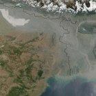
Satellite data shows increasing aerosols over India.
NASA
[NEW DELHI] Aerosols — particles or droplets suspended in the air that impact climate by scattering or absorbing the sun’s radiation — are increasing across India, new research shows.
The findings by S. Ramachandran and colleagues from the space and atmospheric sciences division of the Physical Research Laboratory, Ahmedabad, were published online last month (20 November) in Atmospheric Environment.
Previous Indian studies on aerosols considered India as an entire region or north India as a unit. They also took in just one season, such as winter or the pre-monsoon period from March to May.
In contrast, the new research studied aerosols in 35 locations across India and over the summer and winter seasons, from March 2000 to February 2010.
Scientists measured the 'aerosol optical depth' (AOD), the degree to which aerosols prevent light transmission by absorbing or scattering it, using data from MODIS (MODerate resolution imaging spectrometer), a key instrument aboard two US remote sensing satellites, Terra and Aqua.
They found a rise in annual AOD across 30 locations, while four — Trivandrum in the south and Chandigarh, Dehradun and Shimla in the north — showed a decline. The trends were higher in west and south India.
The annual mean (average) AOD increased by over 40 per cent between 2000 and 2009 in Jaipur, Hyderabad and Bengaluru cities. They rise in AOD over Hyderabad and Bengaluru was attributed to urbanisation, and in Jaipur to increased wind speeds that threw up dust from arid soil.
Similarly, the scientists reported a rise in AOD over New Delhi, attributing it to the burning of fossil fuel and biomass, and an increasing trend in AOD in India’s northeast due to biomass-burning and forest fires.
The study found both AOD and rainfall increased in the last decade in most locations.
"Trends in aerosol characteristics on regional and seasonal scales in India, the focus of this study, are important to examine, understand and explain the effects aerosols have on summer monsoonal rainfall, and the inter-annual variations and trends in rainfall," the report said.
The seasonal and annual trends in AOD over different locations in India will prove useful in the assessments of regional and global climate impact due to aerosols, the scientists concluded.
Jayaraman Srinivasan, chairman of the Divecha Centre for Climate Change and professor at the Centre for Atmospheric and Oceanic Sciences at the Indian Institute of Sciences, Bengaluru, expressed some reservations.
"The use of satellite data to study trends in aerosols over land is not reliable due to the large uncertainties involved in the satellite retrieval of AOD over land," Srinivasan told SciDev.Net.
"One must be wary of mistakenly interpreting noises and biases in satellite aerosol products as legitimate signals in long-term trends analysis," said Srinivasan, who heads a mega Indian research project on black carbon or soot and its environmental impact.
Read in detail at : http://www.cdrn.org.in
Thursday, December 15, 2011
Adapting to Climate Change the Right Way
Faced with more frequent natural disasters caused largely by climate change, global and local decision-makers need to have greater foresight in their efforts to prevent and recover from future crises.
Tropical Storm Irene brought that need home brutally to Vermont, where authorities reacted earnestly but in ways which may worsen damage from future severe weather events. The storm caused little harm in urban areas of the mid-Atlantic and Northeast, so few expected the once-in-a-century flooding in rural upstate New York and Vermont that caused 56 deaths an estimated $10 billion to $15 billion in damage.
Although the damage was surprising, the causes behind it were not. For decades, scientists have warned that human-caused greenhouse gas emissions and the climate change they induce would result in weather extremes that grow more numerous and more intense. Climate change adaptation -- adjustments in natural or human systems in response to the impacts of climate change -- has thus become an international priority.
Such investments in adaptation make sense. Adaptation is necessary if communities and countries are to survive drastic changes in climate once environmental tipping points -- such as acidification of ocean, alteration of the Gulf Stream, or thawing permafrost -- are crossed.
Adaptation can also produce benefits beyond resilience to climate change, such as economic stability, improved environmental quality, community investment, and local employment. In many developing countries, climate change adaptation efforts are being integrated into strategies to reduce poverty. The Asian Development Bank has estimated, for instance, that every $1 invested in adaptation now could yield as much as $40 in economic benefits by 2030.
Global efforts are therefore underway to adapt in the face of droughts, rising sea levels, storms, and floods. The city of Perth in Western Australia, for example, is building a desalination plant to offset losses in water from declining precipitation. Planners in the Netherlands are constructing dikes, dams, and floating houses to cope with increased flooding and rises in sea level. Londoners are investing in a Thames River barrier system to better respond to floods.
Yet some of these interventions can have unintended, and dangerous, consequences. In Vermont, after Tropical Storm Irene, local and state officials allowed an unusual amount of dredging by heavy equipment in stream and riverbeds to collect gravel to help quickly repair roads. These actions, however, reduced the ability for ecosystems to lessen future flood surges, thus making those roads even more susceptible to storms and undermining the repair work itself.
Vermont is not alone in pursuing adaptation methods with unexpected consequences. In the Maldives, nicknamed the "flattest country on earth," poor coastal protection measures such as dredging to create sandbars and erecting seawalls have unintentionally reduced the flow of nutrients to coral reefs, weakening a natural shield against storm swells and surges. Coastal communities there have also removed vegetation to expand settlements and resorts and have mined sand for use in construction. These activities have increased the exposure of the Maldives to rising sea levels and floods. In Uganda, national leaders have planted thousands of hectares of fast-growing eucalyptus and pine trees to "sink" large amounts of carbon and create a buffer against strong winds. Such efforts, however, have inadvertently eroded the vitality of native forest ecosystems and displaced hundreds of communities from their livelihoods and land, lowering overall social resilience.
These examples -- and dozens more like them -- illustrate that sometimes the best intentioned adaptation efforts can increase environmental, economic, or social vulnerability. Part of the explanation may be the ad hoc and frenetic way local, state, and national officials sometimes respond to disasters. Following Tropical Storm Irene, some Vermont state policymakers were so overwhelmed that one local senator publicly announced that "the state became lawless for several weeks." He argued that Vermont's emergency policy amounted to a de facto "Do what you have to do and we'll sort it out later."
Economic incentives, some very understandable, can also play a role in the rush to action. The Ugandan tree planters mentioned above will receive millions of dollars for the carbon credits generated from their project. Vermont businesses, especially those involved in tourism, were anxious to see rapid road, bridge and other repairs completed before the fall foliage and winter ski seasons.
Good intentions, however, aren't enough. Climate change adaption efforts must meet the needs of the localities they intend to serve. The fact that such interventions are often done hastily should make us all the more diligent that they do not accelerate, rather than reduce, risk. Decisions made today on adaptation will greatly determine how vulnerable we are to future climate-induced events. Tropical Storm Irene was a powerful lesson that today's weather-related disaster can become tomorrow's humanitarian crisis.
The challenge now is to ensure that crisis recovery efforts rebuild for long-term resilience. After all, poorly designed and implemented investments in adaptation are worse than none at all.
Fire crisis: Only few hospitals in city prepared
THIRUVANANTHAPURAM:� Ninety-three lives were lost in the blaze that engulfed the AMRI Hospital, Kolkata, last week. How many hospitals in fast-growing Thiruvananthapuram can tackle a similar disaster? ‘Few’ would be the answer. Flawed or non-existent fire-fighting mechanisms and absence of hospital contingency and mass casualty management plans will prove fatal for many hospitals in the city in the event of a similar disaster, experts say.
And this is not a problem confined to hospitals alone.
"The problem is that there is no periodic review of fire safety mechanisms in high-rises. The safety certificate is issued when giving building permit, and there is no subsequent inspection after that. This is a major handicap,’’ says R Viji, project officer of the City Corporation’s Disaster Management Cell.
Last month, the Corporation issued notices to high-rises, including hospitals, to pull� their act vis a vis safety together. The first periodical safety assessment in high-rises, including hospitals, will be carried out this month.
"It will focus on fire safety aspects as well as earthquake preparedness. Many high-rises even lack emergency exits such as fire escapes,’’ she said.
Unlike hotels and apartments, evacuation in hospitals assumes an altogether different dimension. Hundreds of patients, many of them incapacitated, have to be extricated in a matter of minutes, which calls for coordinated effort. But it is a fact that few hospitals have even emergency escape routes marked out.
Absence of hydrants, timely replacement of fire-fighting equipment and general complacency in the matter of fire safety are issues faced by the Fire and Rescue Service Department.
"Periodical inspection is crucial,’’ said K Sivanandan, Director (Technical), Fire and Rescue Service Department. "We have now framed rules for periodical checks in buildings. This will soon come into force,’’ he said.
But it’s not as if the issue of disaster management has never been discussed in hospitals. A few private hospitals have staged mock drills with the help of the Fire and Rescue Service. But government hospitals are more vulnerable when it comes to handling disasters on home patch, according to a senior disaster management official in the state.
On December 2, the Institute of Land and Disaster Management under the Revenue Department, in association with GeoHazards, the global partner of the World Health Organisation (WHO), organised a one-day workshop at the Government Hospital, Peroorkada, on disaster management in hospitals. In Phase II, mock drills are also planned.
(For updates you can share with your friends, follow IBNLive on Facebook, Twitter andGoogle+)
Source :- http://ibnlive.in.com/news/fire-crisis-only-few-hospitals-in-city-prepared/211884-60-123.html
Wednesday, December 14, 2011
Simple tools speed up quake warnings - December 12, 2011
 Researchers have developed a new technique for quickly assessing the magnitude of large earthquakes, cutting down the time required in the case of the recent quake in Japan, for example, from about 20 minutes to just 2-3 minutes. Those crucial minutes would have helped with tsunami warnings and in making sure that even far-away communities like Tokyo had proper alerts as soon as possible, says Yehuda Bock of the University of California, San Diego, who developed the technique.
The strategy involves tying together real-time data coming from seismic instruments, which detect shaking, as well as Global Positioning System (GPS) instruments, which detect the absolute movements of the ground. Both devices are already installed in places such as Japan and California — the key is to ensure that they are delivering the right sort of data simultaneously, says Bock, who reported on his progress at theAmerican Geophysical Union (AGU) meeting in San Francisco, California, on 8 December. Bock and his colleagues this month received funding to build and test a prototype upgrade device, and hope to have an initial system in place in California within six months.
Seismic instruments are very sensitive, but have a hard time discriminating between large quakes of magnitude 7 or higher in the first seconds or minutes of an earthquake, because the shaking simply goes off the scale. In the case of the March 2011 Tohoku earthquake in Japan, for example, the Japan Meteorological Agency estimated the quake's magnitude as just 6.8 after 38 seconds, and 8 after a few minutes, says Bock. It was not until weaker seismic readings from much further away were added to the analysis that they could say, 20 minutes after the quake began, that it was a devastating magnitude 9 — 30 times stronger than a magnitude-8 quake.
Accelerometers add another layer of information, but their data take too long to process to be of use. GPS instruments are more useful. The station closest to the epicentre, for example, showed a 1.5-metre drop of the ground in the first 100 seconds of the quake. "That's huge," says Bock. This provides a quick and obvious indication of large vertical ground displacement — the thing that causes tsunamis — and can be combined with seismic data to quickly assess quake size. But most GPS networks were designed to provide long-term data about ground movement, not short-term information during earthquakes; they may be designed to take readings once every 30 minutes and deliver data once a day, for example. And they aren't necessarily installed next to seismometers. Of Japan's 1,200 GPS stations — all of which are real time — only 180 are close enough to seismic stations to be of use in this sort of system, and so far they haven't been utilized this way.
"Japan's earthquake system is one of the best in the world. But their GPS system, which is also the best in the world, is ignored," says Bock. This is partly because flowing the data together and interpreting them is tricky, and partly because the seismic community hasn't communicated much with the 'geodesy' community that works with GPS signals, says Bock. "There's a separation between communities that we need to fix," he says.
Read in detail at :- www.cdrn.org.in
Saving the Forests with Indigenous Knowledge
By Isaiah Esipisu*

DURBAN, South Africa, Dec 9, 2011 (IPS) - For the Laibon community, a sub-tribe of Kenya’s Maasai ethnic group, the 33,000-hectare Loita Forest in the country’s Rift Valley Province is more than just a forest. It is a shrine.
"It is our shrine. Our Gods live there. We gather herbs from the place. We use it for bee- keeping. It therefore forms part of our livelihood," said Olonana Ole Pulei, who is in Durban, South Africa, to represent his community at the ongoing 17th Conference of Parties under theUnited Nations Framework Convention on Climate Change.
According to Nigel Crawhall, the Director of Secretariat for the Indigenous Peoples of Africa Co-ordinating Committee (IPACC), different African communities have incredible indigenous knowledge that they use in the conservation of forests and biodiversity in general, and this should be recognised during the negotiations in Durban.
"Different communities have different practices that they use in forestry conservation," he said.
Crawhall gave an example of how the Bambuti and Batwa pygmy communities, in the eastern Democratic Republic of Congo, conserved the forest using traditional methods. Both communities depend on the biodiversity of animal life in the equatorial forests in order to survive.
"Usually, they know how to identify particular trees that can be cut down in order to create a unique opening on the canopy, which attracts light in the closely-packed Congo forests. The light then attracts animals, birds and insects, thus giving them an opportunity to hunt," Crawhall told IPS.
This helps conserve the biodiversity, as well as the forests because this method can only work if the forest canopy is intact.
In Kenya, the Maasai culture forbids any community member from cutting down a tree, either for firewood or any other purpose. People are also forbidden from interfering with the taproots or removing the entire bark of a tree for herbal extraction.
According to their cultural belief, one can only use tree branches for firewood, and fibrous roots for herbs. If the bark of a tree has medicinal value, then only small portions of it can be removed by creating a "V" in the bark. The wound is then sealed using wet soil.
"We believe that the soil helps in healing the wound on a tree. This is cultural, and we all believe that it is an abomination for one to injure a tree, and not help it heal," said Ole Pulei.
It is a practice that has been passed down from generation to generation among Maasai community members. Among the Laibon community, it is this indigenous knowledge that has aided in the conservation of the Loita Forest.
"All logging activities observed on Maasai land, including the destruction of the Mau Forest, are done by foreigners because the Maasai culture does not allow such activities. This is the indigenous knowledge that helps in forest conservation," Ole Pulei told IPS.
Such beliefs make the forests part of the community, where community members have feelings for the trees, and where cutting down a tree could amount to an offence against the Gods and their culture.
"We have several other communities all over the continent who co-exist with forests. They include the Tuareg community in Algeria, Yiaku community in Kenya’s Laikipia region, the Ogiekcommunity also in Kenya, the Kung community in Botswana among others," said Crawhall.
Though according to Crawhall, all Africans are indigenous although there are some groups who live by hunting and gathering, while other groups practice pastoralism, and others practice dry-land farming.
Despite the fact that there is no standard definition of indigenous people, the 2007 United Nations Declaration on the Rights of Indigenous Peoples recognises that particular communities, due to historical and environmental circumstances, have found themselves outside the state system and underrepresented in governance.
"The Bushmen of the Southern African region, or the Ogiek community in Kenya who live in forests are a typical example of groupings categorised as indigenous," said Crawhall.
He points out that Africa has more than 40 groupings in different countries that survive entirely on hunting and gathering. However, IPACC works closely with 155 communities from 22 African countries who are recognised as indigenous because of their historical and environmental circumstances.
As a result, representatives from these communities have joined the rest of the world in Durban to have their voices heard, so that their contributions to forest conservation are recognised as part of the climate change mitigation and adaptation efforts.
"We believe that African traditional ecological knowledge is the foundation for appropriate and effective national adaptation policies," said Crawhall.
Through the IPACC secretariat, the 155 community-based organisations in Africa have drafted their position for the Durban negotiation platform. They want the negotiators to come up with a position that is representative to African parties, indigenous African people’s organisations, traditional institutions, traditional authorities and value systems.
They are calling for the formation of a regional body that is legally binding under the United Nations, to handle issues on conservation that are difficult to deal with at national level.
"One of the prevailing gaps in most of the IPACC-member countries is that there is no land tenure for communities who live in forests, or depend on forests," said Crawhall.
However, different countries have started responding to the needs of their local communities by including them in their national climate change adaptation strategies, with Kenya taking the lead.
The country is in the process of drafting the Climate Change Adaptation Bill. And the indigenous communities will have their say on the bill because according to the constitution, they must be consulted on draft legislation so that they can make contributions.
"We have traversed the entire country seeking views on this bill, where local communities have been able to give their contributions. Our vision is to participate and lead in the development and implementation of climate change sensitive policies, projects and activities within and outside our Kenyan borders," said John Kioli, the chairman for the Kenya Climate Change Working Group, who is attending the Durban climate change negotiations.
* This article is one of a series supported by the Climate and Development Knowledge Network.
(END)
Subscribe to:
Posts (Atom)